Ngā mahere hoko whenua
Land sale maps
We hold the largest map collection in Aotearoa New Zealand with over a million maps and plans. Maps that show land transactions are spread across the holdings, and some of these are described in our Land research guides. This guide covers three types of maps that are particularly useful for genealogists: Land Sale Maps, Roll Plans, and some of our earliest maps, the Statutory Branch Registered Maps (known as Series 997).
Land and Survey Land Sale Plans – Land sold by ballot
In Wellington we hold national sets of maps that document the sale of Crown land by ballot. Most are held in two separate but related series: ‘Land and Survey Land Sale Plans’ (Series 8109) and ‘Land and Survey Land Sale Plans’ (Accession W3740).
Searches can be made by settlement name annotated on NZMS13 Index Maps. Sale Plans were issued free to land sale enquirers who may have seen newspaper advertisements, listings in a Crown Land Guide or noticed a sale poster displayed at all NZ post offices, railway stations, public buildings, or at a Crown Lands Office.
All plans included a detailed description of localities and each property. Many later plans were complemented by free brochures (multi-page booklets) averaging 20 pages that included a fold out sale plan minus land description details.
Between 1892 and 1911 the Crown offered 8.5 million acres for settlement under the Land for Settlements Acts. Land considered unsuitable for farming was developed by the Crown into viable farmland, and rather than selling these to the highest bidder, potential buyers registered an interest in purchasing the land at a fixed price. The purchaser for each block was then chosen by ballot. Maps of the land for sale were published and distributed for public viewing at Lands and Survey offices across the country.
The 531 maps in Series 8109 range from 1893-1946 and appear to be the Head Office maps of land offered for sale. They are organised by land district and year and are listed with their Block or settlement name. The ‘Lands and Survey Maps’ in Accession W3740 contains over 6,600 maps. These are organised by district, year, and block/section/settlement.
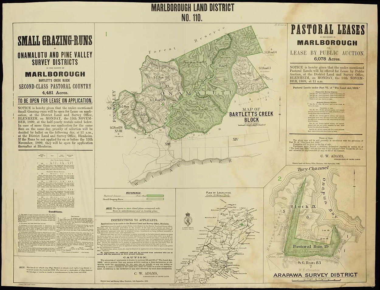
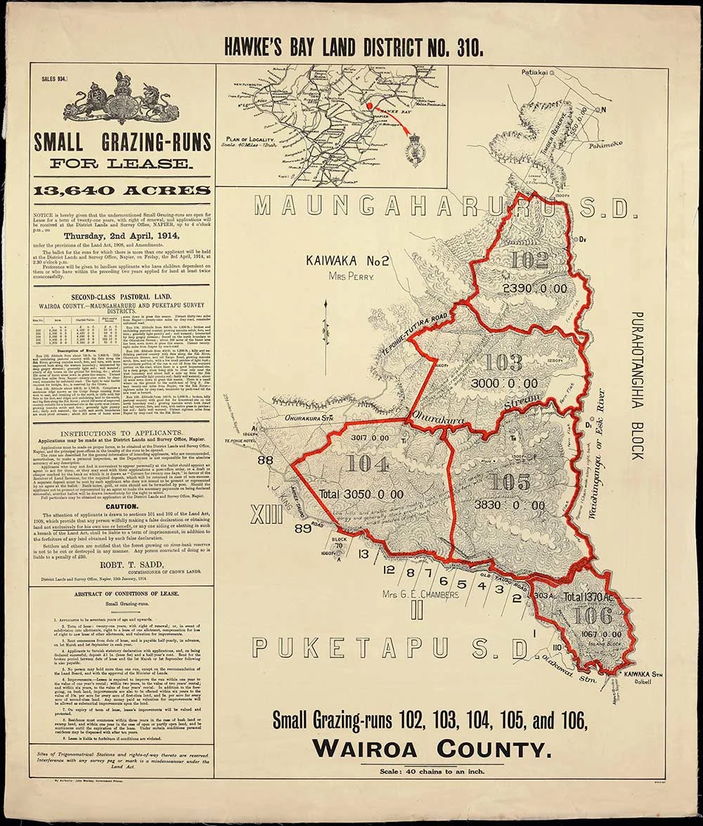
The maps contain:
Survey district, block and section numbers and their chain size
Detailed descriptions of the block or section
The cost of rent for leases
Date and location of the ballot itself
A purchaser’s name is sometimes recorded as an annotation
Topographical information, place names etc
Files on every section that was ever balloted are scarce, but if your ancestor received land by ballot then these maps will help. From newspaper references or other sources, you can match up the section or block to the map for that ballot.
-
![Marlborough Land District No. 110.]() Click to expandMarlborough Land District No. 110AADS W3740 F214/ 15 & AADS W3740 F88/ 110
Click to expandMarlborough Land District No. 110AADS W3740 F214/ 15 & AADS W3740 F88/ 110![Marlborough Land District No. 110.]() Click to expandMarlborough Land District No. 110AADS W3740 F214/ 15 & AADS W3740 F88/ 110
Click to expandMarlborough Land District No. 110AADS W3740 F214/ 15 & AADS W3740 F88/ 110 -
![Hawkes Bay Land District No. 310]() Click to expandHawkes Bay Land District No. 310AADS W3740 F234/ 310
Click to expandHawkes Bay Land District No. 310AADS W3740 F234/ 310![Hawkes Bay Land District No. 310]() Click to expandHawkes Bay Land District No. 310AADS W3740 F234/ 310
Click to expandHawkes Bay Land District No. 310AADS W3740 F234/ 310
Roll Plans
We hold large format roll plans created by the Lands & Survey Department across our four offices. Drawing upon several major plan sequences including Deposited Plans (DP) Māori Land Plans (ML) and Survey Office Plans (SO) and organised into districts, these roll plans show:
Survey districts
Block and section numbers and their chain size
Land blocks and their various boundaries, divisions or allotments (such as crown grants, partitions, confiscations, reserves)
Māori Blocks, reserves, place names and sites of interest (wāhi tapu, pā, kainga, awa etc)
Rural and town sections, often with settler surnames or references listed
Locations and names of early townships, streets and roads
Pastoral runs
Topographical features such as rivers, mountains, forests and vegetation
The Roll Plans are extremely helpful for getting a broad sweep of an area or finding boundaries of sections and blocks. They can help if you don’t have a section number for your ancestor’s land.
Roll Plans are listed on Collections search and may be found by searching ‘district roll plans’, the name of an area, or by SO plan numbers.
Statutory Branch Registered Maps
Some of our earliest and most diverse maps are held in Series 997 or ‘Statutory Branch Registered Maps’. This is a series of around 2,000 maps that were used by the Department of Lands and Survey as reference tools for their work. Although they are held in Wellington they cover all parts of Aotearoa New Zealand, and many are digitised and available to view online.
Most of the maps are arranged by Provincial districts, with divisions into districts, towns and reserves. There are also two very large groups of maps that are not arranged geographically – these are the General and Gazetted maps.
The District maps include:
Military maps of roads, redoubts etc
Block maps
New Zealand Company maps to do with land tenure, sale of land and land sections
Topographical maps
Māori maps on native reserves, confiscated land, pā sites etc
Maps of rivers
Town maps showing subdivisions, sections etc
Reserve maps for railways, municipal etc
Outline maps of districts, rivers, provinces, blocks
Maps of railway lines
The General maps include:
Military data
Population numbers
Electoral information
Iwi/tribal boundaries and census data
Explorer routes Schools
The Gazetted maps cover definitions of areas of control for various government and local government functions, such as:
Electoral districts
Land boundaries
Reserves
Court districts
Mining areas and districts
Sheep and cattle districts
Harbour board boundaries
Water races
The maps vary in format. Some are as small as 20 centimetres square while others can be up to four metres long. Some are hand-drawn and coloured, some are monochrome prints, and some are lithographs.
The maps are useful because they:
Contain the names of land owners, both Pākehā settlers and Māori owners
Show section numbers that locate land cited in other documentation
Provide information about patterns of land use, military activity, travel, settlement and ownership that illuminates former residents’ lives, both Māori and Pākehā

